
UN Endorses New World Map Showing Africa’s True Size; North America And Europe Appear Smaller
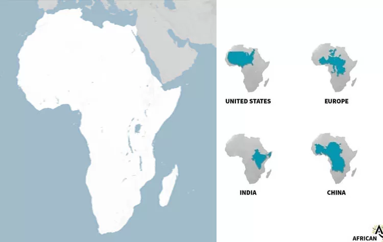
The world may soon look different on maps in schools, the media and on the Internet. The United Nations General Assembly has approved a new world map projection which shows the true size of continents, making Africa appear much bigger than it does on the commonly used Mercator map.
The resolution, backed by Togo and the African Union, was approved overwhelmingly at the United Nations, with 164 countries voting in favor and six abstaining, as well as the United States being the sole opponent.
Why Is Africa Bigger on the New World Map?
For centuries the Mercator map has been one of the most popular projections of the world. It was created in the 16th century for navigators, who needed to be able to maintain direction easily, which the Mercator achieves, but the map greatly distorts the size of various places, especially near the North and South Poles.
Because of this, Africa appears much smaller than it actually is, while areas such as Greenland, Europe and North America can appear much bigger than they are.
One of the most noticeable examples of the Mercator projection exaggerating the size of an area is Greenland, which can look about the same size as Africa on a Mercator map, while in reality, Africa is about 14 times bigger than Greenland.
What Is the Equal Earth Projection?
The UN-approved resolution advocates for the use of an alternate, relatively modern world map projection called the Equal Earth projection. Unlike the Mercator, the Equal Earth is designed to show the true sizes of various continents and land masses. This means Africa will look much bigger, while some other areas, particularly in the northern part of the map, will appear smaller than they do on the Mercator.
The goal of the resolution is not to completely ban the use of the Mercator projection, but rather to promote the use of more accurate maps such as the Equal Earth for educational purposes and in digital media. The UN resolution calls on nations and other entities to consider whether they should continue using inaccurate projections for maps, for education and for digital media.
Why Does the New Map Matter?
Proponents of the new map believe that not only do maps show the location of different places, but they can also affect the perception of distance and space between them.
The African Union and the "Correct the Map" campaign have said that Africa has suffered greatly from being depicted on maps much smaller than it actually is for centuries.
The "Correct the Map" campaign has called for governments, schools, international organizations and technology companies to use more accurate maps which depict the continents with their true sizes.
Will the Mercator Map Disappear?
Not immediately.
The UN resolution is not an order for all nations to stop using the Mercator projection immediately. The projection has practical uses such as navigation and will likely continue to be used for such purposes, despite the new resolution.
However, the new resolution may lead to more organizations using the Equal Earth projection or similar ones for maps which are meant to be educational or otherwise use the Mercator projection.
Why Is the Decision Being Called Historic?
The resolution is historic because it is not just a readjustment of how continents are depicted on maps, but also a step towards having a more consistently accurate depiction of the world on maps.
The controversy over the use of different projections on world maps has been going on for centuries, since the very first maps were being produced, since every projection, including the Mercator, is inherently inaccurate and distorts the size, distance or shape of certain areas. The recent decision by the United Nations is a reminder that the inaccuracies of the Mercator can affect the way many people view the world.
Africa should be allowed to grow on maps used by schools, the media and online platforms, potentially reaching millions of people every day, showing just how big the continent actually is.
Tags Cloud